Hello everyone! I’m toni, a developer in the app team here at Datawrapper, and this week, in an unintended continuation of last week’s topic, I look at intersections with the most accidents in my town.
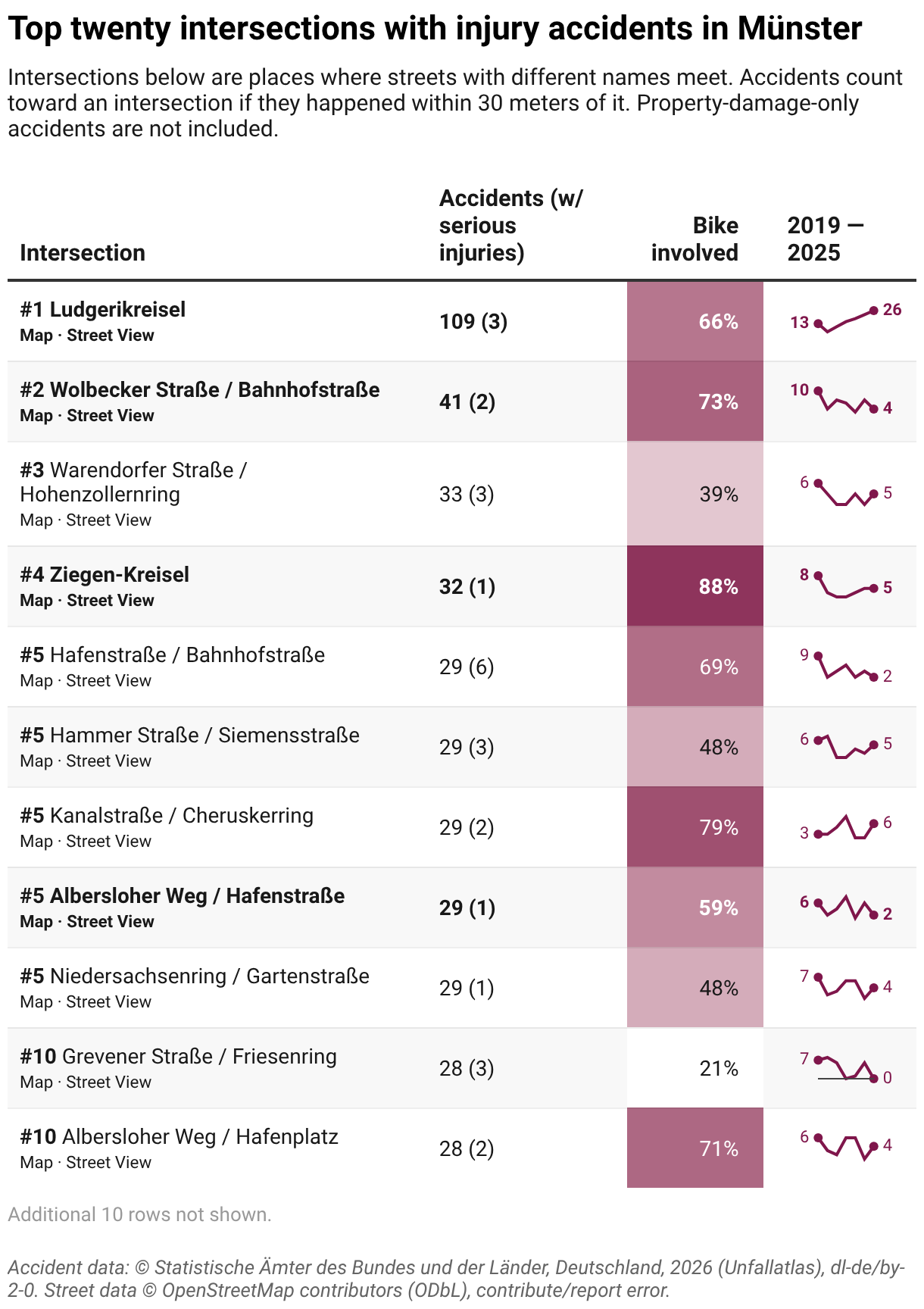
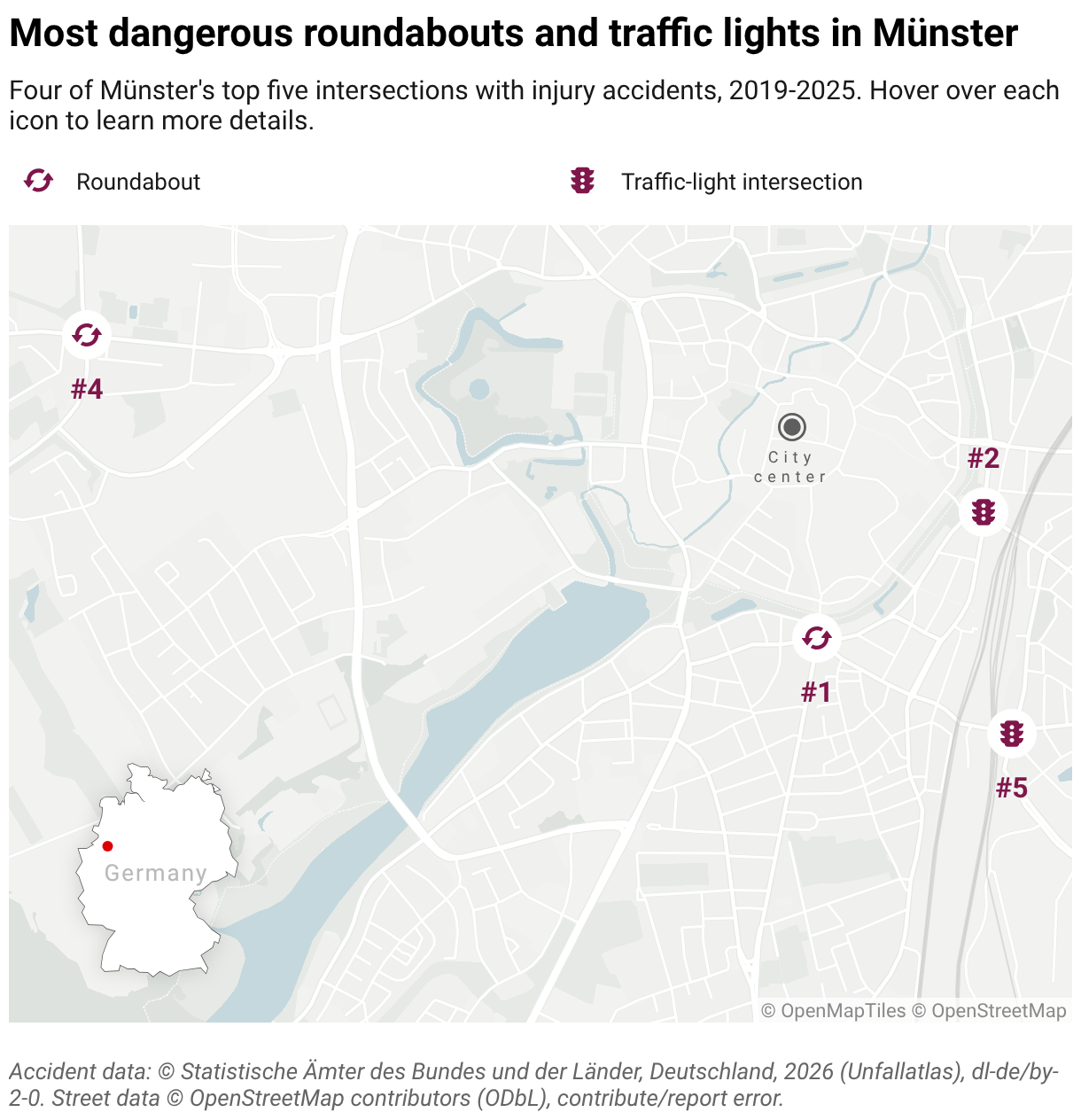
I live in Münster, which is a lovely city in the German region of Westphalia. It’s known as the “bike capital of Germany”, and it consistently ranks high in the Fahrradklima-Test, a bicycle-friendliness survey. However, when I’m at a big intersection, waiting for the green light while cars pass me by, I can’t help but think that “this city is still very much car-centered, like most other German cities”. I took a look at the available data and came up with this:
Right off the bat, I saw my most subjectively miserable-feeling intersections climb to the top of this ranking. Let’s start with number one, Ludgerikreisel: It’s infamous for being a two-lane roundabout close to the center of the city, connecting six different streets. There is so much traffic that riding a bike or driving a car there is always nerve-wracking. It’s consistently been a hot spot for accidents. Last year, it reached the highest accident rate in the state of North Rhine-Westphalia, despite Münster being only the tenth largest city by number of residents. At least as a pedestrian you always get the right of way because of the marked crosswalks, but it still feels somewhat miserable to walk along all of this traffic, even if the center has some trees and is home to many squirrels.
But there’s some good news. Recently, the city repainted the road from Ludgeristraße to reserve a lane for buses and cyclists, leaving only one for cars. Even though it’s a small restructure, it feels a lot safer now to enter the roundabout on a bike, and it’s always nice to take back even a tiny bit of space from cars. We’ll see if this change makes a difference in the rankings.
I was quite surprised to see number four, the Ziegen-Kreisel roundabout, rank so high since it’s very popular with bikes. The city council voted to turn the roundabout into a traffic-light intersection, but a citizens’ initiative collected over 18,000 signatures to keep the roundabout. Compared to a traffic-light intersection, they argue, an optimized roundabout would reduce the risk of serious accidents, keep the traffic flowing, be easier to navigate for cyclists and pedestrians, take up less space, keep trees where they are, and be cheaper to run. The city council has now stopped their plans, and instead wants to optimize the existing roundabout. It’s amazing to see people get together, organize, and have their voices heard!
On the other hand, number two, Wolbecker Straße / Bahnhofstraße, feels like a huge mess: counting very generously, thirteen incoming lanes from five different streets meet here, and I’m not even counting the bike lanes. Another intersection I pass pretty regularly is Albersloher Weg / Hafenstraße (one of five intersections tied at #5), which seems to be designed to waste time, because as a cyclist or pedestrian, you always have to wait at least once, or even multiple times, to cross the road.

Even though I have been ranting a lot, I still really love living in Münster. It’s a big enough city so all needs are covered, from shopping and entertainment to queer spaces, but at the same time it’s not so big that you feel drowned out by all the concrete. While the road design still is very car-focused, the Promenade makes getting around the city very quick and enjoyable by bike, and the inner core of the city is very walkable.
Getting the data into shape
For this Weekly Chart, I used a script to fetch the data, sort it by intersection, count accidents, and create Datawrapper-ready CSV files.
The data is based on two main sources. The first is the Unfallatlas, a collection of all accidents with injuries recorded by German police. The script downloaded all available years for North Rhine-Westphalia and filtered for accidents in Münster.
Next, I used Overpass API to get Münster streets from OpenStreetMap and group them into intersections. This was the trickiest part: I basically collected all OpenStreetMap nodes where multiple streets with different names meet. Nodes within 25 meters of each other got merged into one intersection, as did all nodes of a roundabout, plus a few intersections were merged by hand.
An accident within 30 meters of an intersection node was counted towards that intersection, taking the closest one if several applied. The rest of the script was pretty straightforward again, ranking intersections by number of accidents, and outputting them as CSV, ready to import into Datawrapper.
The script can be found here.
Thanks for reading! Did you find the success of the citizens’ initiative as inspiring as I did? Tune in next week for a new Weekly Chart from my colleague Ivan!